

KONGSBERG Supplies Technology Suite for NIOZ RV Anna Weber-van Bosse

KONGSBERG has supplied a comprehensive package of advanced ocean science and navigation technologies for RV Anna Weber-van Bosse, the new ocean research vessel owned and operated by Royal Netherlands Institute for Sea Research (NIOZ).Christened on the island of Texel in early March, the 80-meter newbuild has been outfitted with a range of innovations including HiPAP acoustic positioning systems, EM304 and EM2040 multibeam echosounders, TOPAS sub-bottom profiling technology, advanced echosounders for water column observation…
Anschuetz Adds Generic Overlay for SYNAPSIS ECDIS NX

Anschuetz has added the Generic Overlay feature, which extends SYNAPSIS (W)ECDIS NX by enabling the direct display of external, geo-referenced data within the chart. Third-party systems can provide their information as overlay layers, visualized seamlessly alongside standard navigational data in a consistent spatial context.Based on a standardized, generic interface, external applications can be connected to the Electronic Chart Display and Information System (ECDIS) itself without any modification.
Oman, Iran Discuss Managing Strait of Hormuz Navigation

Oman and Iran agreed on Tuesday to press on with discussions about the future administration of navigation in the Strait of Hormuz, including maritime services in the strategic waterway and the costs associated with them.In a joint statement issued after talks in Muscat, the two countries said a joint working group involving their foreign ministries would be formed to continue the discussions and that they would consult other littoral states and relevant parties.The move appears…
UK Hydrographic Office Launches Digital Format for ADMIRALTY Sailing Directions

The UK Hydrographic Office (UKHO) has launched ADMIRALTY Digital Sailing Directions (ADSD), transforming its Sailing Directions navigational guides into an interactive digital format. Designed to simplify passage planning and increase situational awareness, ADSD moves Sailing Directions beyond static guides to a dynamic and searchable digital tool. The launch of ADSD marks a milestone in the UKHO’s ongoing efforts to develop digital solutions that are safe, compliant and aligned with the evolving needs of mariners.
Lloyd’s Register Announces Nigerian Future Navigators Schools Program Pilot

Lloyd’s Register (LR) is launching its Future Navigators Schools Programme pilot in Lagos, Nigeria, aimed at inspiring young people to explore maritime and STEM (Science, Technology, Engineering and Mathematics) careers through in-person interactive workshops and a bespoke mobile game. The pilot program engaged students more than 270 young people, aged 14–16 across three schools in Lagos, combining in-person learning with digital tools designed to make maritime and STEM subjects more accessible, relevant and engaging for younger audiences.
DNK Launches Program for Assured Positioning, Navigation and Timing Services

Den Norske Krigsforsikring for Skib (DNK) has launched a program to provide members access to Assured Positioning, Navigation and Timing (A-PNT) services to counter the growing risk of jamming and spoofing.DNK, Norway’s leading war risk mutual insurance provider, has launched a program to offer members advanced systems to protect against the growing threat of Global Navigation Satellite System (GNSS) signal interference. This industry-first program allows members to select among vendors specializing in A-PNT services to lower premiums and provide secure…
AMI Marine Receives Panama Approvals for SMIDS Pro GNSS Speed Log

AMI Marine has passed approvals for their ACP (Panama Canal Authority) Non‑Portable Piloting Aid (NPU) option for the SMIDS Pro GNSS Speed Log system.These new approvals further strengthen the SMIDS Pro portfolio and confirm its suitability for vessels requiring reliable, compliant, and future‑ready speed and distance measurement solutions.This next‑generation system introduces new features, including:High‑precision GNSS‑based speed and distance measurement, and headingEnhanced operational reliability and performance…
ChartWorld, Raymarine Commercial Unify Under Single Brand

Teledyne Technologies Incorporated announced the unification of ChartWorld and Raymarine Commercial under a single commercial navigation brand, Raymarine Commercial. As part of the unification, ChartWorld’s commercial navigation solutions and services will transition fully into the Raymarine Commercial brand, further strengthening Teledyne’s position as a global leader in maritime navigation solutions and demonstrating the successful integration of acquired businesses into its core operations.The combination brings ChartWorld’s established digital navigation…
Lloyd’s Register Live Trials Orca AI's Navigation Technology Onboard Vessel

Lloyd’s Register (LR) has tested Orca AI's AI-powered navigation system during a live vessel trial.The assessment focused on how AI-based computer vision can support human decision-making in real operating conditions, particularly in complex navigation scenarios such as congested waters and reduced visibility.The trial was conducted on a feeder containership during a five-day voyage through some of the Mediterranean’s busiest shipping lanes, from the port of Gioia Tauro in Italy to Marsaxlokk, Malta.
Study From Orca AI, NorthStandard Highlights Role of of AI on Navigational Safety

A large-scale operational study conducted jointly by Orca AI and leading P&I club NorthStandard marks the first time an AI navigation provider and marine insurer have combined large-scale operational data to quantify the real-world impact of AI on navigational safety.Based on data from a globally operating cohort of 139 vessels, the study found that deployment of Orca AI’s platform resulted in a 52% reduction in high-severity close encounters over 12 months, with an initial 22% reduction achieved within the first six months.The study examined more than 10.8 million nautical miles of voyages…
Anschütz SYNAPSIS Nav Tech for New Multipurpose Vessel

Anschütz has been awarded the contract to supply Integrated Navigation and Bridge Systems (INBS) for three multipurpose vessels being built for the German Waterways and Shipping Administration (WSV) at the Abeking & Rasmussen shipyard. The first of these, the Scharhörn, has successfully completed a series of sea trials and is nearing delivery.Anschütz equips these ships with SYNAPSIS INBS technology. SYNAPSIS offers a high level of integration and automation, providing the crew with clear and precise information about the maritime environment to support safe navigation…
STAPEM Ops for Sonardyne’s Precise Positioning System
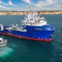
France-based STAPEM Group has chosen Sonardyne’s Ranger 2 Ultra-Short BaseLine (USBL) technology as the permanent solution for one of its flagship offshore support vessels, the STAPEM Boreale.Operating in one of STAPEM Group’s key regions, Angola, the vessel is now equipped with a Ranger 2 GyroUSBL 7000 system, an all-in-one, high-performance USBL system for precise positioning performance, previously used on a hire basis.Ranger 2 GyroUSBL 7000 is optimized for ultra-deepwater operations and, like all Ranger 2 GyroUSBL systems, includes a single, pre-calibrated transceiver head.
Steering Failure Caused Vessel to Make Contact with Navigational Aid
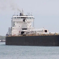
A steering system failure led to a bulk carrier’s contact with a navigational aid in the St. Marys River near Sault Ste. Marie, Michigan, according to the National Transportation Safety Board.The bulk carrier American Mariner struck the Munuscong Channel Junction Light on March 28, 2024, as it was transiting upbound in the St. Marys River. The Munuscong Channel Junction Light is comprised of a navigational light and signal mounted on a concrete, fixed structure.After the contact the vessel began taking on water but was stabilized using pumps.
Anschütz Rolls Out Navigation and Command System for Autonomous Navy Ops
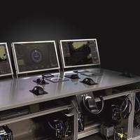
German navigation specialist Anschütz has developed a navigation and command system for autonomous and unmanned maritime operations. The approval-ready system has undergone extensive testing in autonomous operation and is currently being prepared for use in prototypes, according to the company.The autonomous navigation and command system from Anschütz provides navies with a sustainable capability and safety enhancement for unmanned systems. It ensures autonomous navigation and control and operation of unmanned platforms…
Ireland Elected to the Council of IALA

Ireland has been elected to the Council of IALA, the International Organisation for Marine Aids to Navigation. IALA was founded in 1957 and has recently transitioned into an inter-governmental organization. The Irish Government ratified the IALA Convention in May 2023, marking a milestone in Ireland’s commitment to international co-operation in maritime safety and to shaping the future of global navigation.The election of Ireland to the new IALA Council took place during the inter-governmental organization's inaugural General Assembly in Singapore on February 20, 2025.
Misinterpretation of Aids to Navigation Contributed to Vessel Grounding

Following the grounding of one of its pilot transfer launches in Port Phillip Heads, Australia, a Port of Melbourne pilotage services provider has developed additional operational guidance on the use of launch equipment and crew resources.On the evening of October 5, 2023, the pilot launch Corsair was returning through the entrance of Port Phillip after collecting a pilot from an outbound container ship, when it ran aground on Point Lonsdale Reef travelling at about 24 knots.The coxswain…
NOAA Guides Easier Hudson River Navigation
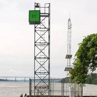
Real-time data on coastal conditions will support improved maritime navigation in New York.Navigating New York waterways just got a bit easier. NOAA and the New York State Department of Environmental Conservation announced the establishment of the Hudson River Estuary Physical Oceanographic Real-time System (PORTS). The system delivers real-time oceanographic and meteorological observations that can improve maritime safety and inform coastal resource management in the region.
IALA Becomes Intergovernmental Organization

After more than 10 years of work and four diplomatic conferences, The International Association of Marine Aids to Navigation and Lighthouse Authorities (IALA) has officially changed from a non-governmental organization (NGO) to an Intergovernmental Organization (IGO).The transition to an Intergovernmental Organization will place IALA in a much stronger position to develop and harmonize Marine Aids to Navigation, as governments will be directly involved in the work. All major decisions will be made by representatives of their governments…
NAVTOR Releases NavFleet Emissions Simulator

NAVTOR, an e-Navigation and performance technology provider to the maritime industry, said Wednesday it was aiming to simplify CII compliance with the latest release of its NavFleet ship operations platform. Featuring an advanced Emissions Simulator, designed to help shipping companies predict and optimize environmental impact and performance across entire fleets, NavFleet 1.8 delivers operational insights built on high-quality, dual-validated data, the company said.The result…
Major Port Hedland Navigation Project Completed
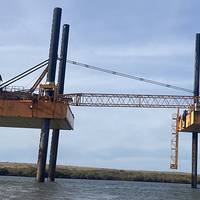
The Australian Maritime Safety Authority (AMSA) has completed a major A$15.5 million two-year project to repair and rejuvenate essential aids to navigation (AtoNs) off the coast of Port Hedland, Western Australia.AMSA commissioned the works following Severe Tropical Cyclone Veronica in 2019, which caused significant damage to electrical equipment, access ladders, platforms, day markers and fenders.AMSA has replaced the top of 13 AtoNs, installed new platforms and above water pile sections…
Furuno's Berthing Aid System Receives ClassNK's Endorsement
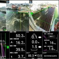
Japanese classification society ClassNK has granted its Innovation Endorsement for Products & Solutions to a Berthing Aid System developed by Furuno.Furuno's Berthing Aid System displays the distance and angle between the ship and the quay to assist in berthing operations.The Berthing Aid System uses LiDAR to calculate the relative distance and angle between the quay and hull, and displays superimposed images for situational awareness. The system aims to improve safety during berthing by measuring and visualizing the positional relation between the quay and ship…
Sensor Systems Improve Marine Navigation Near US Naval Bases
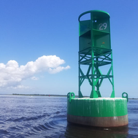
Maritime navigational safety near two U.S. Navy installations in Kings Bay, Ga., and Portsmouth, N.H. has been improved thanks to new Physical Oceanographic Real-Time Systems, also known as PORTS, installed by NOAA and the U.S. Navy. They are the first new PORTS in two years, and the 34th and 35th in the nationwide network.The system near Naval Submarine Base Kings Bay, the East Coast home to America’s Ohio-class submarines, is an integrated series of sensors which will provide critical real-time information on oceanographic and meteorological conditions.
SevenCs Releases ORCA Pilot X Software
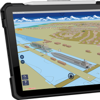
SevenCs, part of the ChartWorld Group, announced the release of ORCA Pilot X software. Originally designed as a primary navigation aid for Pilots, ORCA Pilot X is a tool for professional navigators. ORCA Pilot X is being offered as a free download on the Apple AppStore for iOS tablets.SevenCs has a long tradition of developing bespoke navigation applications for pilots around the world. Following the feedback and input from many users, SevenCs began the development of ORCA Pilot X as the natural evolution from ORCA Pilot G2.Ralf Lehnert…



