
Phase 1 of S-100 Implementation Complete
Phase 1 of S-100 Standards implementation is now complete after the operational release of standards S-124 Navigational Warnings and S-128 Catalogue of Nautical Products.The S-100 framework is a new global standard created by the International Hydrographic Organization (IHO), in collaboration with other hydrographic offices around the world, that enables the integration of diverse datasets within a single Electronic Chart Display and Information System (ECDIS) or other hydrographic…
NV5 Advances Hydrography in the Great Lakes: Join the August 27 Live Webinar
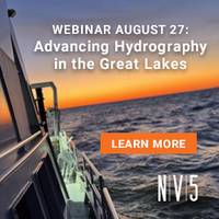
NV5 has unveiled its latest precision hydrography innovations in the Great Lakes, enabling maritime stakeholders to “Own the Lakebed, Master the Mission." To showcase these breakthrough capabilities, NV5 will host a free, live webinar on Wednesday, August 27 at 1:00 PM CT/ 2:00 PM ET, offering a deep dive into how integrated hydrographic, terrestrial, and lidar data are transforming infrastructure planning and environmental monitoring in the region.From shoreline restoration to subsea cable routing and coastal resilience projects…
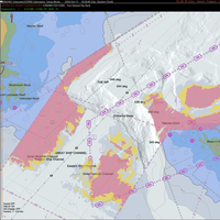
Canada Trials S-100 on St. Lawrence River
The Canadian Hydrographic Service (CHS), under Fisheries and Oceans Canada, is taking a leading role in validating new digital hydrographic standards, with the Minister of Fisheries, Joanne Thompson, launching S-100 sea trials on the St. Lawrence River.The S-100 data model is a new global standard created by the International Hydrographic Organization (IHO), which offers a new way of visualizing the marine environment using layered, interactive digital data that can be added to navigational charts.
IHO Member States Adopt S-100 Operational Standards
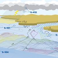
International Hydrographic Organization (IHO) member states have adopted the first set of operational standards within the S-100 framework.The S-100 framework enables the integration of diverse datasets within a single Electronic Chart Display and Information System (ECDIS). Mariners will now be able to combine various data layers such as Electronic Navigational Charts (ENCs), detailed depth information and dynamic information on water level and currents to enhance situational…
Musicians Create Underwater Symphony
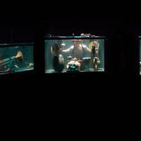
Teledyne Marine has collaborated with BetweenMusic, a Danish performance company led by musicians Leila Skovmand and Robert Karlsson, to create an underwater concert experience known as AquaSonic.The music ensemble worked with Teledyne Marine’s hydrophones to perform all the music in AquaSonic underwater.Your web browser does not support iframes, which means that the video AquaSonic: The Underwater Symphony Perfected with Teledyne Marine Hydrophones cannot play.Water absorbs high frequencies more readily than air…
Wreck of MV Noongah Identified
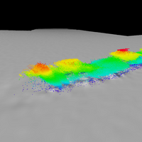
CSIRO, Australia’s national science agency, has helped confirm the resting place of motor vessel (MV) Noongah, a 71-metre coastal freighter lost at sea in 1969 in one of the nation’s worst post-war maritime disasters.MV Noongah was travelling between Newcastle and Townsville carrying steel when it encountered a storm and sank in heavy seas on 25 August 1969.The loss of MV Noongah led to one of the largest searches for survivors in Australian maritime history, involving navy and merchant vessels…
Ukraine Working to Prep Black Sea Ports for Grain Exports
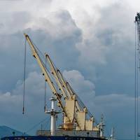
Ukraine's navy confirmed on Wednesday that work had started at three Ukrainian Black Sea ports aimed at preparing for the resumption of grain exports."In connection with the signing of the agreement on the unblocking (by Russia) of Ukrainian ports for the export of grain, work has been resumed in the ports of Odesa, Chornomorsk and Pivdeny," the navy said on Facebook."The departure and arrival of ships to seaports will be carried out by forming a caravan that will accompany the lead ship."(Reuters - Reporting by Aleksandar Vasovic and Pavel Polityuk, Editing by Timothy Heritage)
USACE Galveston Taps eTrac for $13M Hydrographic Surveying, Mapping Contract

The shared capacity, indefinite delivery contract will support USACE Civil Works projects to help advance navigation safety, dredging, flood control and hurricane response.The U.S. Army Corps of Engineers Galveston District awarded eTrac, a Woolpert Company, with an architect-engineer contract to provide hydrographic surveying and mapping services within the Galveston District and potentially the USACE Southwest Division. The five-year, Multiple Award Task Order Contract has a total shared capacity of $13 million.
Paramount Launches another Boat for S. African Navy
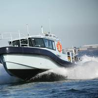
Paramount Maritime launched its second of three next-generation Survey Motor Boats (SMBs) for the South African Navy in a move that will enhance the capabilities and infrastructure of the South African Navy Hydrographic Office (SANHO). This follows the launch of the first Survey Motor Boat to the South African Navy in August 2020.Veecraft Marine, a subsidiary of Paramount Maritime, had been tasked with the design and manufacture of the three Survey Motor Boats, all of which having taken place in their shipyard in Cape Town…
Nigeria Pledges Improved Information Sharing

The Nigerian Maritime Administration and Safety Agency (NIMASA) and the Nigeria Navy are set for a regime of improved information sharing as arrangements to integrate the Command, Control, Computer Communication and Information (C4i) Cente of the Deep Blue Project along with the Falcon Eye of the Nigerian Navy.The Director General of NIMASA Dr. Bashir Jamoh said, “Just like we did by ensuring that our Special Mission Vessels are manned by men of the Nigerian Navy, we are also looking at the possibility of effectively linking the C4i center at kikiriki with the Falcon Eye of the Nigerian Navy.