Platform Allows Ships to Share Real Time Data on Navigation Hazards
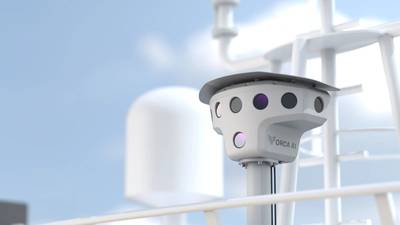
Maritime technology company Orca AI has launched Co-Captain, a new function in its operational platform that allows vessels can share data with each other, in real time, to be better prepared for real-time events and emerging risks.
By connecting a growing network of 1,000 Orca AI-installed vessels, with hundreds more set to join, Co-Captain turns every ship into both a sensor and source of awareness, says the company.
Building on Orca AI’s advanced computer-vision technology, Co-Captain fuses these fragmented inputs into a single layer of collective intelligence. The result is a constantly evolving picture of each vessel’s route that keeps crews ahead of risk.
Each Orca AI-equipped vessel acts as a node in a trusted global network, continuously detecting high risk targets, including non-AIS targets such as fishing vessels, small craft, and navigational hazards like fishing nets. Each vessel continuously uploads data to the cloud, where it is processed to trigger relevant alerts based on specific events. These alerts can include high traffic (congested waters), GPS interferences, severe weather, and more. Alerts are sent to vessels on intersecting routes, enabling timely adjustments to speed, course or watchkeeping, helping crews stay safe and in control.
“This could very well be the most accurate crowdsourced navigational engine in shipping,” said Yarden Gross, CEO and Co-Founder of Orca AI. “Every addition to the fleet strengthens that shared awareness, enhancing how ships anticipate risk and support one another.”
The database constantly updates what is happening on global routes, Gross adds. “All data is fully anonymized, with only the location and observed conditions reported, ensuring complete privacy.”
Co-Captain delivers verified, route-based notifications tailored to each vessel's exact operational context, including:
Congested waters: Alerts based on live traffic density and recent close encounters, enabling early speed or course adjustments, or an additional OOW to be assigned.
Severe weather: Real-time warnings, including Beaufort Scale readings and visibility data, enables crews to prepare well in advance.
GNSS interference: Any satellite signal interference detected by other Orca AI vessels is relayed in real time, allowing crews to re-route or rely on alternative navigation methods. Warnings about areas prone to spoofing and interference are also sent.
Piracy zones: Alerts before entering high-risk areas, prompting activation of security protocols and increased vigilance.
Environmental compliance: Automated updates on whale sightings and early alerts prior to entering whale-protection zones, emission-control areas and local speed limits, giving crews time to prepare in advance to ensure full regulatory adherence.
Navigational hazards: Buoy shifts, unmarked obstacles, ice, man-overboard incidents and pollution can be reported between vessels. Co-Captain also relays critical updates on temporarily closed or restricted areas.


